Up Raebrueti

Sitemap
 
Contact

Snapshots

 
E

N

G

L

I

S

H
Home
Hiking
Walks
Infos
Transport
Imagemap
Links
GPS
UK_flag Summary
 
D

E

U

T

S

C

H
Home
Wandern
Spazieren
Infos
Transport
Imagemap
Links
GPS
D_flag Summary
 
Schweizer Seiten

ISOS
Ortsbilder
Heritage sites

Zugerberg

Map: Wanderkarte Zugerland 1:25000.

Zugerberg is a popular  area for walking and recreation. A very special attraction is the moor. Large areas are protected. Especially for crossing the moor you should use the well marked tracks.

The most convenient way for getting here is by using Bus 11 (Zug-Schoenegg), there change to the funicular. 
From Schoenegg to Zugerberg there is also a walking track.
  

ZGBergbahn.jpg (35571 Byte)

Funicular Schoenegg-Zugerberg

Access for private car is by way of Baar (via Allenwinden), Zug (Blasenberg), or Walchwil. A parking Lot is at "Hochwacht" (near Vordergeissboden). From here driving is restricted (No driving on Sunday's: Sonntagsfahrverbot)

There are a  Children's playground and some fireplaces about 800 m from the cable car station. The walls, trenches and bunkers nearby are remainders of the precautions in WWII.

Pfaffenboden: This easy walk will guide you through alternating scenery's and will reward you with pretty lookouts. The moor "Eigenried" is a rare and very special area.
Pfaffenboden by Panoramaweg: An other easy walk, this one brings you along the western flank of Zugerberg, providing fantastic views.
Zug - Zugerberg - Unteraegeri. An easy, interesting route with pleasant Restaurants at "strategic points". Use a All day bus ticket, a "Tageskarte" (Funicular fare included).
Zug - Zugerberg - Allenwinden. As above, another easy route. As an add-on you may proceed to Wildenburg/Tobelbruecke and on to Hoellgrotten or Baar using lovely tracks.
Zugerberg-Sibrisboden-Allenwinden: A lovely Hike, passing also a hitoric WWII landmark.
Zugerberg-Sibrisboden-Neuaegeri: As above but End at Neuaegeri.
Raebrueti, playground, Ewegstafel: This short trip may be interesting for family's who are more interested for a picnic or the children's playground. 
Raebrueti, map and pictures of Sculptures

Top of page

Zugerberg km  hrs
Zug - Zugerberg (Bus, funicular)    
Zugerberg-Felsenegg-Ewegstafel- Fruehbuehl-Buschenchappeli-Pfaffenboden 5 1.5
or Panoramaweg:
Zugerberg-Felsenegg-Ob.Horbach-Lienisberg-
Tossetschwaendi-Schwaendi-Balis-Stafel-Pfaffenboden
7.5 2
Pfaffenboden-Buschenchappeli-(Hintergeissboden, or Fiselstuden/Raebrueti-Huenggiguetsch)-
Vordergeissboden-Zugerberg
4.5 1.2
or: Pfaffenboden-Langmoesli-Ochsenfeissi (Sonnegg)-Unteraegeri 6 1.5
Zugerberg - Zug (funicular, Bus)
or: Unteraegeri - Zug (Bus)


Zugerberg, Boden - Unteraegeri km  hrs
Zug - Zugerberg (Bus, funicular)    
Zugerberg-Vordergeissboden-Huenggiguetsch-Saetteli
Tubenloch, Boden, Unteraegeri
5 1.2
Unteraegeri - Zug (Bus)    


Zugerberg, Brunegg - Allenwinden - Baar km  hrs
Zug - Zugerberg (Bus, funicular)    
Zugerberg-Vordergeissboden-Huenggiguetsch-Saetteli-
Brunegg-Allenwinden
4.5 1
Allenwinden-Wildenburg-Tobelbruecke 2.5 0.5
Tobelbruecke-Oberallmend-Baar 4.5 1
Baar - Zug (Bus, Train)    


Zugerberg, Raebrueti, Spielplatz, Ewegstafel km  hrs
Zug - Zugerberg (Bus, funicular)    
Zugerberg-Vordergeissboden-Huenggiguetsch-
Raebrueti-Ewegstafel-Zugerberg
5 1.5
Zugerberg - Zug (funicular, Bus)    

Top of page

Schoenegg to Zugerberg walk

There are good walking tracks right from the station in Schoenegg (bus / funicular transfer). Allow about 90 minutes for the forest walk up to Zugerberg.

One of the roads runs for the first 300 m parallel to the funicular track. 
Where the road hits the Bitumen road to Zugerberg we choose the Bitumen road. The path to the left would be a detour by Blasenberg, under crossing the rail track.

After about 15 Minutes we are again on the walking track and 20 Minutes later we arrive at the turnoff to Zugerberg. It's a narrow, steep track with some stairs. 

At the top, where the track ends we're at the Bitumen road Zugerberg to Walchwil. The  track nearby will guide us to Ewegstafel, after a short ascent.

Top of page

Pfaffenboden

Eigenried

Eigenried

The track begins at the Zugerberg station (Restaurant with fantastic view), after crossing the Bitumen road. It's an easy walk along the rim to Ewegstafel. Walking along Felsenegg, the hotel - like building belongs like many others to the alpine school "Montana". 
Walking on from Ewegstafel to Fruehbuehl (a former military penitentiary) we're crossing a unique moor area.

At Fruehbuehl the road to the left runs along an alley of birch trees  towards Buschenchappeli. Here is a lovely place with chapel, some shady trees and fireplaces. About 150 m from there to the right will be the Restaurant Pfaffenboden with large Terrace and interesting panorama. 

At Fruehbuehl, during the summer half year, you may be fascinated by the hundreds of swallows crisscrossing the sky. They have their nests under the big roof of the stable and are constantly feeding their youngsters. The parents seem not to care about the amazed hikers.

The road to the right, after the stables, runs to Pfaffenboden Restaurant and terrace. 
From Pfaffenboden we choose the road to Buschenchappeli. 

At Buschenchappeli there are many options for either going on back to Zugerberg station or Aegeri. A forest track to the right will bring us back by Raebrueti to the funicular station.
 

Buschenchappeli, Rigi Moor lake in Eigenried
Buschenchappeli. 
In the Background Rigi.
Moor lake in Eigenried. 
After turnoff near Ewegstafel.
map for moor lake Map for moor lake

Top of page

Zug - Zugerberg - Unteraegeri

From Pfaffenboden it's about 1 hr to Unteraegeri. Walking on along the straight Bitumen road for a kilometer we reach a crossing: sharp to the right the road leads to Walchwil. Proceeding to the left (sign "Alpli/Wildspitz") we are soon passing two other crossings. We follow the signs for "Ochsenfeissi". At the second crossing, a fairly large place used for parking and storing lumber we turn left and are now on a nice forest track. After a short time we will arrive at the hamlet Ochsenfeissi with the popular Restaurant Sonnegg which can be reached by car from Unteraegeri. From here to Unteraegeri it's about half a 40 Minutes walk to the bus stop at Unteraegeri.

Alternative

Ascending the road behind Restaurant Vordergeissboden, you reach "Huenggiguetsch-Saetteli" (5 min). Up there are two roads for Unteraegeri to choose from. The road by "Boden" will descend conveniently to Boden (some shooting ranges a ski lift and a popular Restaurant) and then to the village center (40 plus 20 min).

Top of page

Zug - Zugerberg - Allenwinden

Ascending the road at Vordergeissboden we reach "Huenggiguetsch-Saetteli". The Bitumen road, here making a left turn, will lead to Brunegg, Schmittli. The road will leave the forest after about 30 minutes at Brunegg. 

Soon after the Restaurant, at the fountain we choose the track to the left, for Allenwinden, Wildenburg, Baar. There are pretty views over the wooded valleys and over to the Gubel. There are remainders of the former glacier in this area.

In Allenwinden we may catch a bus back to Zug. 
Walking for about 300 m along the main road towards Baar, on the right we find the track for Wildenburg, Tobelbruecke. The walk is along the gorge of a little river. 
Near Wildenburg we cross and after a short while we're at the bus stop Tobelbruecke. 
Here again, we may proceed either to Hoellgrotten, (deep below) or to Baar on excellent walking tracks in and along the forest.

Zugerberg-Sibrisboden-Allenwinden

6 km, 1.5 hrs. 

Leaving the Zugerberg Station, turning left we pass Restaurant Vordergeissboden and ascend on the Bitumen road to Huenggi Guetsch Saetteli. We stay on that road for a short while. After the bend and some 200m a marked track to the right zigzags down to Sandblatten, there leaving the woods.

Huenggi.jpg (47281 Byte)Now 
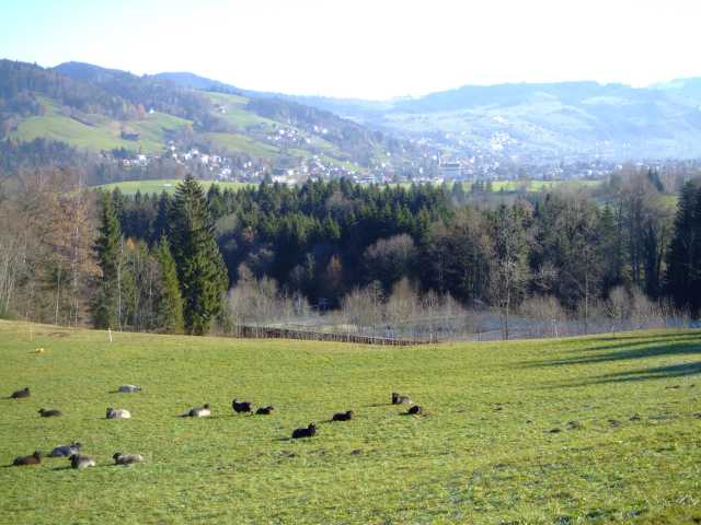
at the Huenggi, the terrain is gently sloping down to Unteraegeri, presenting lovely vistas.

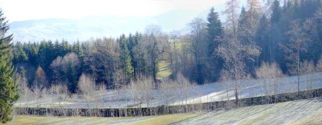
Some way down, after the big slope around the Hubertus Chalet, a  Sibrisboden.jpg (19748 Byte)long wall, actually a trench inside two concrete walls, catches the eye. During WWII the 600m long Tank trap was part of the “Reduit” fortification. See “history”.

At the crossroads we turn left, towards Brunegg. After some 500m the road makes a sharp bend to the right, but we proceed straight ahead. 

The trail now runs along the edge of the forest, along the fringe of Zigermoos, and later we’re in the woods for another 500m. Leaving the trees, 
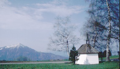
the view opens and the Albis-chain is front. To the right the little church from Gubel is visible.

Near Brunegg (summer Restaurant, some 150m to the left) we cross the Bitumen road and on a dirt track by way of Unterstock we reach Zugerbergstrasse.

After some 100m on that Bitumen road, on the left a path along Schwarzenbach creek is leading down to the main road Baar-Allenwinden.

A Bus stop is at Restaurant Loewen, some 200m down the main road.  

Zugerberg-Sibrisboden-Neuaegeri

5 km, 1.3 hrs

After Sibrisboden at the crossroads we follow the Bitumen road to the right for Raemselbrueggli. After some 600m a field track to the left guides us to the bridge over Raemsel creek. Here we have several options to proceed to Unteraegeri. 

We turn left and follow the excellent Wanderweg along Raemselbach to the main road Zug-Aegeri. 

The nearest Bus stop is at Restaurant Roessli.

Top of page

Pfaffenboden by Panoramaweg

From the funicular station the track runs towards Felsenegg Ewegstafel. After hitting the Bitumen road and a short walk in the forest we are passing a plain and soon reach Ober Horbach. We proceed and pass many farm houses and fields, very often we can enjoy superb views over Zugersee.

For Stafel the road gets a bit steeper, but soon enough we're at the crossroads Alpli/Wildspitz and Buschenchappeli. Going to the left we're in about 15 Minutes at Pfaffenboden. Buschenchappeli we'll pass soon while on the way back by Fiselstuden, Raebrueti, Huenggiguetsch, Vordergeissboden.

Top of page

Raebrueti, playground, Ewegstafel

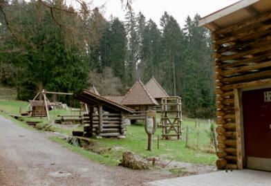
The quickest way to reach the children's playground "Schattwaeldli" from the station is by using the hiking track in the general direction  "Buschenchappeli". 
Or from the parking at Vordergeissboden walk on along the Bitumen road.
Each way takes about 15 minutes.

If you're more interested in walking, you ascend the road behind Restaurant Vordergeissboden up to Huenggiguetsch Saetteli. 
There turn right to Raebrueti. 
Later instead of turning right and down to the playground go straight on for a while. Later you cross over to Ewegstafel and on to the funicular station.

spielpl1.JPG (22554 Byte) spielpl2.JPG (16429 Byte)
Playground

Above the playground are about a dozen sculptures, carved out of tree trunks. Most are forest animals. Remarkably, only the chain saw has been used.
Perhaps this could lead to a interesting game: Where was which animal?

The sketch shows the approximate places.

Hikers who prefer short routes, find here an interesting and diversified scenery along with pretty lookouts.

At Vordergeissboden there is the option of making the short detour up to Hochwacht:
At the parking ascend along the Wanderweg up to the hilltop. An unmarked track leads over to the Antenna site and down the hill. After 100 m a service road on the left will hit after another 100 m the Bitumen road coming up from Unteraegeri to Zugerberg. For the proposed hike you have to turn right and after about 100 m ascending on the Bitumen road you reach the Wanderweg at Huenggiguetsch Saetteli.

Top of page

Zugerberg, map Sketch showing the hiking track Raebrueti-Ewegstafel 
and approximate position of sculptures.
Perhaps a kind of orienteering run: 
where is which animals?
Results: A4, B5, C1, D6, E10, F7, G9, H3, J8, K2 


Interesting Links with topic forest
Wald-Site www.wald.ch/
Tierpark
Goldau
www.tierpark.ch
Ferrets www.swissferret.ch/

Top of page


Up ] Raebrueti ]