Baarburg
Baarburg is the name of the dominating hill to the east of Baar. The
geometrical form and the cave (Erdmandliloch: ~hole of earth trolls) have
probably animated the fantasy.
Anyway, a round tour and/or the climb is rewarding.
To the Top
| Zug - Baar (Bus 3 or 14 to "Brauerei" or
"Laettich") |
km |
hrs |
Brauerei-Schiessstand-Bruederhus-Chriesibrunne-
Baarburgboden Rundweg-Aussichtspunkte-Chriesibrunnen-
Bruederhus-Schiessstand-Brauerei |
5 |
2 |
From bus stop Brauerei (Brewery) we walk along the former
spinning mill
to the roundabout, then straight ahead up to the Schiesstand (rifle
shooting range).
At the parking a road is leading to Bruederhus and Chapel
"Heiligkreuz", then on into
the forest. Later a track will cross a little gully and after
some stairs we're again on a forest road. The trail proceeds in a steady
ascent to our lookout.
During the rifle shooting you may prefer the other, unmarked road:
along the parking, straight on and after a while into the forest. There,
after hitting an other track, turn left. After 100 m you're on the
"official" walking trail again.
 |
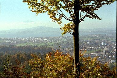
View West. Top of Pilatus just out of the fog |
The top loop offers two lovely lookouts: To the West the view stretches
over Baar, the Zugersee to Pilatus. To the South: Zugerberg and Rigi. At
the southern lookout there is a fireplace and a shelter.
Baarburg round tour
| Zug - Baar (Bus 3 or 14 to "Brauerei" or "Laettich") |
km |
hrs |
Brauerei-Schiessstand-Bruederhus-Chriesibrunne-
Baarburgrank-Walterswil-Chriesibrunnen-
(option Chriesibrunnen to top and back)
Bruederhus-Schiessstand-Brauerei |
6
|
2
+.8 |
Partly, we're using the same trail as above, but we save the climb to
the top and enter the hilly scenery behind the mountain. At Baarburgrank
(a sharp bend in the main road Baar-Neuheim) we follow that road for about
50 meters. Then we turn left for the road to Walterswil. After about 20
Minutes we're there. There is a church and the "International School
of Zug" (www.isoz.ch).
Here, we choose the track to the left, it runs above church and school
property's into the forest again. In a steady ascent we surround the
western part of the hill and finally reach the starting point.
|